Mountain Fire
Ventura County, CA
Acres
1,000
Containment
–
Status
Active
Updated 2 minutes ago
Created by Watch Duty • Nov 6, 2024 at 8:55 AM
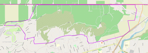
Evacuation Order – Level 3 – Go
Zones 1, 2, & 3
Reference the map. This includes, but is not limited to:
- North Lewis Rd to Los Posas Country Club to North of Loop Drive (Camarillo Heights Area)
- Unincorporated Somis
- West to: Saticoy Country Club
- East to Balcom Canyon Road
- South to Highway 118
Evacuation Notes
VC Emergency Official Information Source
• Staff Reporter
13 minutes ago · Nov 6 at 11:23 AM
All resources are focusing on life safety and evacuating Camarillo Heights, per radio traffic. If you feel threatened, evacuate. See evacuation map above highlighting this area. All evacuations can be viewed at the link here.
A total of 50 strike teams (250 engines) have been requested.
• Reporter
25 minutes ago · Nov 6 at 11:12 AM
Incident Command is requesting to upgrade evacuations to include Los Posas from Lewis to Central Avenue, with a total of 30 strike teams any type requested.
• Reporter
29 minutes ago · Nov 6 at 11:07 AM

An additional evacuation zone has been ordered in Camarillo, and is now visible at https://vcoes.maps.arcgis.com/apps/dashboards/e15ca0d2737d43cea6514043e61f1a7c
• Reporter
34 minutes ago · Nov 6 at 11:02 AM
Incident Command is requesting additional mutual aid aircraft from LA County or LA City. Any Type I or Type II rotor wing. Due to structure threat and threats to infrastructure.
• Staff Reporter
38 minutes ago · Nov 6 at 10:59 AM
Incident command has requested evacuations from N. Loop Drive to Mission, to Valley Vista on the West, with potential warnings to Ponderosa Drive in Camarillo. Evacuations are also being requested for the Sterling Hills area. Units are being sent for structure protection. There are two spot fires south of Highway 118.
• Staff Reporter
An hour ago · Nov 6 at 10:50 AM
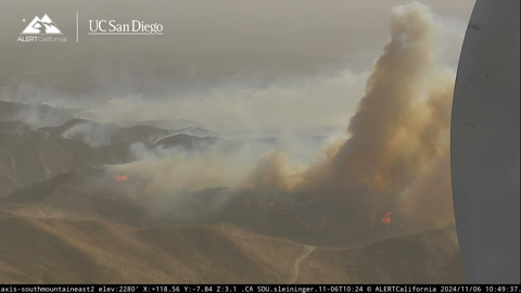
The fire has become established in the Camarillo Heights area, per radio traffic. Units to respond to Las Posas and Arnell. Additionally, the fire is said to have crossed Highway 118. Ten strike teams (50 engines) have been ordered to the incident.
Image is from the South Mountain AlertCalifornia | UC San Diego fire camera.
• Reporter
An hour ago · Nov 6 at 10:40 AM
From VC Emergency the current road closures include:
- Northbound Lewis Road at Las Posas
- Eastbound Highway 118 at Wells Road
- Westbound Highway 118 at Tierra Rejada Road
• Reporter
An hour ago · Nov 6 at 10:24 AM
Incident Command is now requesting a hard closure on the 118 between Wells to Grimes Canyon. Request to close all access to arteries feeding into 118 to emergency vehicles and evacuations only. Additional strike teams were requested earlier.
• Reporter
2 hours ago · Nov 6 at 10:04 AM
Operations is requesting a hard closure at the 118 freeway, west at Wells Road, and East to Grimes Canyon Road.
• Reporter
2 hours ago · Nov 6 at 10:02 AM
Fixed wing will not be able to operate due to high winds. The fire is now 1000 acres, per Air Attack. Seven additional water dropping helicopters have been requested. Fire is expected to spot into the Camarillo Heights area, per Incident Command.
• Reporter
2 hours ago · Nov 6 at 9:59 AM
Incident Command has requested a hard closure on highway 118 between Balcom Canyon and Bradley Road. Air attack plane is now over the fire, along with two tankers and numerous copters.
• Reporter
2 hours ago · Nov 6 at 9:43 AM

An Evacuation Order has been issued for Zone 2, which is west of the earlier Evacuation Order Zone. For the zones’ parameters, see the Watch Duty Map or VCEmergency.
• Reporter
2 hours ago · Nov 6 at 9:40 AM
8 engines have been requested, any type, for life safety and structure defense. Report of structures being impacted near Bradley and Coyote. In addition, 4 additional fixed wing aircraft have been request, any type, with no divert, per Incident Command.
• Reporter
2 hours ago · Nov 6 at 9:35 AM
The evacuation zone for the Mountain Fire is now visible on the Watch Duty app.
• Reporter
2 hours ago · Nov 6 at 9:31 AM

An evacuation order zone has been issued by Ventura County OES. A map of the current evacuation order is shown above. Current evacuations can be found at https://vcoes.maps.arcgis.com/apps/dashboards/e15ca0d2737d43cea6514043e61f1a7c
• Reporter
2 hours ago · Nov 6 at 9:25 AM
Report that the fire has crossed Bradley and approaching the 118, per units on the scene.
• Reporter
2 hours ago · Nov 6 at 9:22 AM
Fire is now 250 acres with potential for 2000, with multiple structure threats and evacuations expected west of the fire, per Incident Command. Two copters have been ordered for structure protection.
• Reporter
2 hours ago · Nov 6 at 9:14 AM
Request to close Bradley Road, fire is spotting over Bradley Road and structure protection requested between Balcom Canyon Road and Solano Verde, per radio traffic.
• Reporter
2 hours ago · Nov 6 at 9:08 AM

Units on scene report a large scale brush fire. Pushed by strong East wind. Structures threatened and infrastructure threatened, upgraded to second alarm. Fixed wing was requested earlier. Both strike teams have been requested to scene. Evacuation orders have been requested by incident command for north of Bradley Road Balcom Canyon west to Kings Grove Road, North and South.
• Reporter
3 hours ago · Nov 6 at 8:58 AM
Wildfire is visible on the South Mountain Alert California | UC San Diego fire camera; units report a medium-moderate header and have requested CHP for road control.
• Reporter
3 hours ago · Nov 6 at 8:55 AM
Possible vegetation fire reported at Balcom Canyon, with smoke visible on Alert California cameras.