T-storms forecast for Friday night

RyanWeather.Com

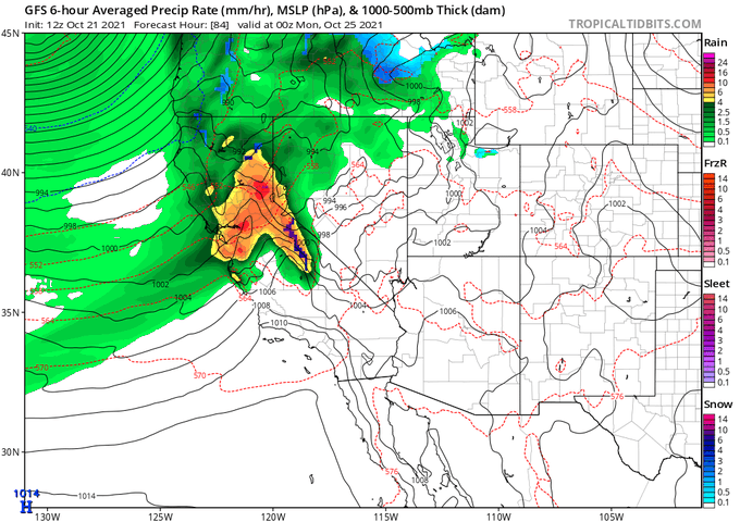
9m  · The Storm Prediction Center has issued a general thunderstorm risk for areas in light green on the map below for Friday into Saturday. This does include portions of Curry, Coos, southern Douglas, Josephine, Jackson, Klamath and Siskiyou counties. These thunderstorms will likely be isolated in nature given that instability aloft is just enough to generate a few lightning strikes and rumbles of thunder.

No photo description available.

Excessive rainfall expected in regions of Northern California

⚠️A HIGH Risk of Excessive Rainfall is in effect for portions of Northern California tomorrow. A strong atmospheric river will produce rainfall of 8-10 inches in the region, leading to significant and life-threatening flash floods and mudslides, particularly over burn scar areas. pic.twitter.com/FvACBTpNID— NWS Weather Prediction Center (@NWSWPC) October 23, 2021

Flood watch in effect

South Central Siskiyou County-
Including the cities of Dunsmuir, McCloud, and Mount Shasta
446 AM PDT Sat Oct 23 2021

...FLOOD WATCH IN EFFECT FROM LATE TONIGHT THROUGH SUNDAY
AFTERNOON...

The National Weather Service in Medford has issued a

* Flood Watch South Central Siskiyou County in northern California.

* From late tonight through Sunday afternoon

* Periods of moderate to heavy rainfall are expected late tonight
  into Sunday afternoon resulting in additional rainfall amounts
  of 2 to 3 inches. This rain, combined with recent heavy rains is
  expected to bring quick rise on areas streams and creeks.

* Small streams and creeks could reach bankfull or even flood during
  this time period. Areas with poor drainage could see significant
  ponding of water in low lying areas. No main stem river flooding
  is expected at this time. Land slides and rock falls will be
  possible during this time of moderate to heavy rain.

Watch for flood/debris issues around burn areas Sun/Mon

The substantial amount of water delivered by these early-season storms will be primarily beneficial (likely ending fire season across NorCal), but high rain rates could also bring some flood/debris flow problems on Sun/Mon, esp. near wildfire burn areas. #CAwx#CAfireQuote Tweet

Daniel Swain@Weather_West · 1h Models now targeting late Sun into Mon period for potentially strong #AtmosphericRiver event in northern and/or central CA. Ensemble mean brings strong AR conditions. Worth noting that control run brings even more intense conditions, but is at upper end of ensemble envelope.#CAwx8:24 AM · Oct 20, 2021·Twitter Web App

Red Flag Warning for Sac Valley, foothills

Red Flag WarningRed Flag Warning is effective from 10/12/2021, 3:30 AM through 10/12/2021, 7:00 PM

Areas Affected: Central Sacramento Valley including Glenn, Colusa, Yuba, Northern Sutter, Butte County Below 1000 Ft; Eastern Delta; Eastern Mendocino NF; Northern Motherlode From 1000 to 3000 Ft. From Yuba To Amador Counties; Northern Sacramento Valley to Southern Tehama County Line Below 1000 Ft; Northern San Joaquin Valley in San Joaquin and Stanislaus Counties Below 1000 ft – Excludes the Delta; Northern Sierra Foothills from 1000 to 3000 Ft.