Red Flag WarningRed Flag Warning is effective from 8/27/2021, 8:00 AM through 8/28/2021, 11:00 AM
Areas Affected: Central Sacramento Valley including Glenn, Colusa, Yuba, Northern Sutter, Butte County Below 1000 Ft; Eastern Mendocino NF; Eastern Portion of Shasta, Trinity NF; Northern Sacramento Valley to Southern Tehama County Line Below 1000 Ft; Northern Sierra Foothills from 1000 to 3000 Ft. Includes Nevada-Yuba-Placer RU and Anador-Eldorado RU; Southeast Edge Shasta, Trinity NF and Western Portions of Tehama, Glenn RU
Summary: …Red Flag Warning Friday morning through Saturday morning for portions of the Sacramento Valley and surrounding foothills… .Gusty northerly winds will develop early Friday morning across the northern half of the Sacramento Valley and surrounding foothill terrain. There may be a brief decrease in winds Friday evening before locally gusty winds return late Friday night through More Info
The long range is showing a cool trough approaching the northstate around September 1. This could result in a significant wind event with cold dry air blowing to the south and west.
[F]ears are growing for Platina as the Mcfarland fire has now reached Hiwy36. Today will be critical….hopefully the winds stay light (as forecast). Unfortunately, not only Platina is on this morning’s hit list. Here’s a quick roundup of the bigger fires and key threatened communities….but note only north Hayfork, Taylorsville and Platina are in imminent danger ATTM.
McCash/Cronan – Happy Camp Haypress – Etna/Trinity Center Monument – Hayfork and Weaverville (+ many other smaller communities such as Junction City). Dixie – Taylorsville, w/possible run towards Susanville in the longer term.
3m · Antelope Fire, Planning some firing out today on the Western flank. Should put up some smoke. McCloud FD, Engine 1712 will be assigned to this operation today in support of the Hotshots.
US StormWatch@US_Stormwatch·A new wildfire start in the Sierra Foothills, the #AirolaFire, is spreading at an extreme rate, near Vallecito and Angels Camp in an area with no recent significant fire history.
Unofficial sources state it’s over 500 acres, in terrain not burned or cleared recently, and exhibiting “an extreme rate of spread.”
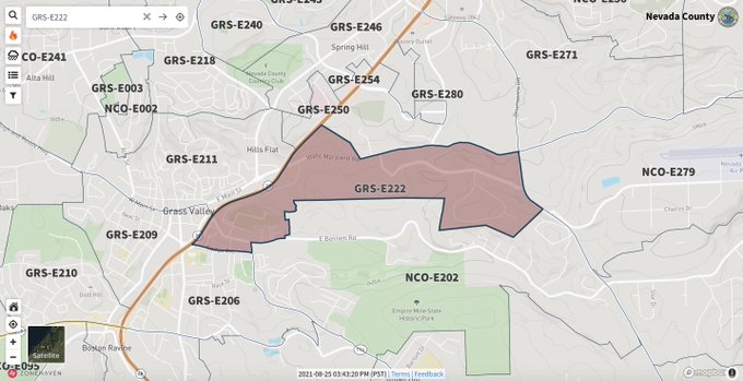
A new incident in Nevada County has caused this zone to be placed under Evacuation Order as of 3:50 PM on August 25. The #BennettFire started just after 3:30 PM in the area of Whispering Pines. Follow incident updates at https://hubs.la/H0V_Ydh0@YubaNetFire
Fire Weather WatchFire Weather Watch is effective from 8/27/2021, 8:00 AM through 8/28/2021, 11:00 AM
Areas Affected: Central Sacramento Valley including Glenn, Colusa, Yuba, Northern Sutter, Butte County Below 1000 Ft; Eastern Mendocino NF; Eastern Portion of Shasta, Trinity NF; Northern Sacramento Valley to Southern Tehama County Line Below 1000 Ft; Northern Sierra Foothills from 1000 to 3000 Ft. Includes Nevada-Yuba-Placer RU and Anador-Eldorado RU; Southeast Edge Shasta, Trinity NF and Western Portions of Tehama, Glenn RU
Summary: …Fire Weather Watch Friday morning through Saturday morning for portions of the Sacramento Valley and surrounding foothills… .Gusty north to northeast winds will develop Friday morning across northern and central portions of the Sacramento Valley and surrounding foothills and may continue into Saturday morning. These winds, combined with low humidity and extremely dry fuels, More Info