Firefighters hope to take advantage of a break in the winds Thursday morning as they continue to battle the Mountain Fire in Ventura County that has already scorched thousands of acres and destroyed dozens of homes.
The fire broke out around 9:30 a.m. Wednesday near Balcom Canyon Road and Bradley Road, north of State Route 118. Initially reported as a 50-acre fire fueled by brush and Santa Ana winds, it jumped the highway and exploded to over 14,000 acres by Wednesday night.
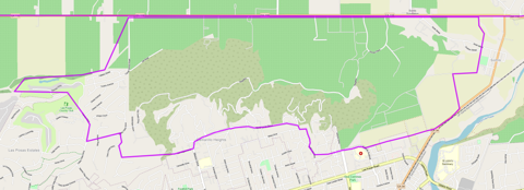
According to Cal Fire, the fire was mapped at 14,500 acres and had no containment as of 7 a.m. Thursday.
Sky5 aerial view of home ablaze from the Mountain Fire in Ventura County, California on Nov. 6, 2024. (KTLA)A firefighting helicopter drops water on the Mountain Fire in Ventura County, California. Nov. 7, 2024. (KTLA)A firefighter pulls a hose in front of a burnt house as the Mountain Fire scorches acres in Camarillo Heights, Camarillo, California, on November 6, 2024.(Photo by ETIENNE LAURENT/AFP via Getty Images)A firefighter attempts to control the blaze burning a house as the Santa Ana wind-fed Mountain fire scorches acres, in Camarillo, California, on November 6, 2024. (Getty Images)The Mountain Fire is seen from Sky5 during the early morning hours on Nov. 7, 2024. (KTLA)A house is engulfed in the flames of the Mountain Fire as the wildfire scorches acres in Camarillo Heights, Camarillo, California, on November 6, 2024. (Photo by ETIENNE LAURENT/AFP via Getty Images)Sky5 aerial view of homes destroyed in the Mountain Fire in Ventura County, California on Nov. 6, 2024. (KTLA)Sky5 aerial view of a brush fire in Somis, California on Nov. 6, 2024. (KTLA)Sky5 aerial view of home ablaze from the Mountain Fire in Ventura County, California on Nov. 6, 2024. (KTLA)Sky5 aerial view of home ablaze from the Mountain Fire in Ventura County, California on Nov. 6, 2024. (KTLA)
A firefighting helicopter drops water on the Mountain Fire in Ventura County, California. Nov. 7, 2024. (KTLA)
1 / 9
A firefighting helicopter drops water on the Mountain Fire in Ventura County, California. Nov. 7, 2024. (KTLA)
Video showed countless homes burning as the fire raged throughout the day and night. The exact number of homes destroyed is still unknown as officials say it is still too dangerous to survey the area.
Fire officials said thousands of homes in Moorpark, Camarillo, Camarillo Heights and Santa Paula remained threatened Thursday morning. Mandatory evacuations have forced more than 10,000 people from their homes.
All resources are focusing on life safety and evacuating Camarillo Heights, per radio traffic. If you feel threatened, evacuate. See evacuation map above highlighting this area. All evacuations can be viewed at the link here.
A total of 50 strike teams (250 engines) have been requested.
Incident Command is requesting to upgrade evacuations to include Los Posas from Lewis to Central Avenue, with a total of 30 strike teams any type requested.
Incident Command is requesting additional mutual aid aircraft from LA County or LA City. Any Type I or Type II rotor wing. Due to structure threat and threats to infrastructure.
Incident command has requested evacuations from N. Loop Drive to Mission, to Valley Vista on the West, with potential warnings to Ponderosa Drive in Camarillo. Evacuations are also being requested for the Sterling Hills area. Units are being sent for structure protection. There are two spot fires south of Highway 118.
The fire has become established in the Camarillo Heights area, per radio traffic. Units to respond to Las Posas and Arnell. Additionally, the fire is said to have crossed Highway 118. Ten strike teams (50 engines) have been ordered to the incident.
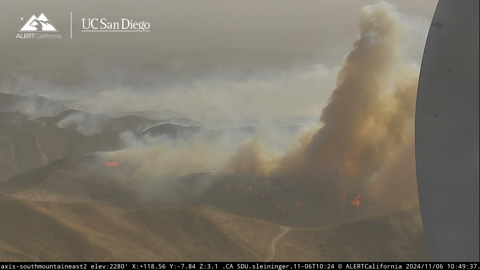
Image is from the South Mountain AlertCalifornia | UC San Diego fire camera.
Incident Command is now requesting a hard closure on the 118 between Wells to Grimes Canyon. Request to close all access to arteries feeding into 118 to emergency vehicles and evacuations only. Additional strike teams were requested earlier.
Fixed wing will not be able to operate due to high winds. The fire is now 1000 acres, per Air Attack. Seven additional water dropping helicopters have been requested. Fire is expected to spot into the Camarillo Heights area, per Incident Command.
Incident Command has requested a hard closure on highway 118 between Balcom Canyon and Bradley Road. Air attack plane is now over the fire, along with two tankers and numerous copters.
An Evacuation Order has been issued for Zone 2, which is west of the earlier Evacuation Order Zone. For the zones’ parameters, see the Watch Duty Map or VCEmergency.
8 engines have been requested, any type, for life safety and structure defense. Report of structures being impacted near Bradley and Coyote. In addition, 4 additional fixed wing aircraft have been request, any type, with no divert, per Incident Command.
Fire is now 250 acres with potential for 2000, with multiple structure threats and evacuations expected west of the fire, per Incident Command. Two copters have been ordered for structure protection.
Request to close Bradley Road, fire is spotting over Bradley Road and structure protection requested between Balcom Canyon Road and Solano Verde, per radio traffic.
Units on scene report a large scale brush fire. Pushed by strong East wind. Structures threatened and infrastructure threatened, upgraded to second alarm. Fixed wing was requested earlier. Both strike teams have been requested to scene. Evacuation orders have been requested by incident command for north of Bradley Road Balcom Canyon west to Kings Grove Road, North and South.
Due to recent precipitation across most of Northern California, wildfire risk is low during this first low RH/wind event and will likely stay below extreme levels during the second event as well from about the SF Bay Area northward (though with some caveats). This is the benefit of early season precipitation: even though most places in NorCal are actually running behind the seasonal-to-date average for Sep-early Nov (a decidedly noisy statistic!), places that have seen half an inch or more of rain recently will be in pretty good shape. Given that there has not yet been a seasonal green-up yet in most places and conditions will still be quite windy with low humidity for an extended period this week, there may still be some fires (especially in grassland settings) up north–but the likelihood of something big or concerning is fairly low up north (event compared to the mid-Oct event). With no further precipitation expected this week, however, and with the cumulative drying effect of several days of windy/low RH conditions expected to be substantial, it’s still a good idea to prevent errant sparks from igniting unplanned/unwanted fires during this period.
“An active fire season continued during this period–considerably later than usual in many parts of the Rockies, stretching already dwindling seasonal fire crews thin. In California, while fire activity has again picked up relative to the comparative August lull, no highly destructive fires have occurred over the past month despite vegetation moisture levels approaching or exceeding record dryness levels for October at times (though there have been a few near misses). And a fair number of risk-reducing prescribed burns have been able to go forward on the less windy days–always encouraging to see. Meanwhile, the Bridge and Line fires in the SoCal mountains (which originally ignited in early September) have continued to flare up on occasion, but generally these have been interior pockets of vegetation burning and have not burned any further structures.”
[…]
“Fire season continues across central and southern CA; risk will continue to spike during offshore wind events
Although we have not seen a major autumn wildfire outbreak yet in California, we also haven’t seen widespread season-mitigating (let alone season-ending) rainfall south of the about the I-80 corridor. In fact, vegetation moisture levels in parts of SoCal are now approaching record levels again following the early October heat and more recent dry winds–and even in the Bay Area conditions remain drier than average for the time of year. So fire season continues from about the SF Bay Area southward (less so to the north, where more widespread rain has fallen on a couple of occasions now and more will fall over the next week). That means that critical fire weather conditions can and probably will arise a couple of times over the next 10-14+ days, especially in the SoCal mountains and coastal plain where dry offshore Santa Ana winds (and relatively warm conditions) are expected periodically. Right now, none of the Santa Ana events in the forecast appear to be particularly extreme–but the magnitude of these events can be tricky to predict very far in advance as they are quite sensitive to the exact placement and depth of “inside slider” low pressure systems over the Great Basin (of which there will be at least a couple). So until widespread soaking rains arrive–and that is not looking likely south of about San Francisco for the next 2+ weeks–fire season will remain active and be punctuated by occasional higher-risk periods.”
NOTE: Significant rain is expected in our local starting Sunday and continuing for several days. Snow showers are possible. It won’t bring an end to fire season, but it does bring about a respite.
Berkeley Hills residents urged to leave homes Friday night due to ‘extreme fire weather’
Berkeley Hills residents are asked to leave their homes by 8 p.m. Friday. BFD’s alert came as an acres-wide fire burned to the east in the Oakland Hills, prompting evacuations.
Residents living in Berkeley Hills neighborhoods shown in blue on the Berkeley Emergency Map are urged to preemptively leave their homes Friday evening. Evacuation warnings and orders will be shown on the same map in yellow and red. Credit: Zoneaware
The Berkeley Fire Department has declared a state of “extreme fire weather” from 8 p.m. Friday until 7 a.m. Saturday, recommending anyone in the Berkeley Hills preemptively evacuate their homes and head downhill before that 8 p.m. start time.
“Extreme fire weather” is a designation specific to Berkeley that takes effect when wind speed and humidity levels during a “red flag warning” — a National Weather Service designation, which took effect Thursday — “would produce especially risky conditions in Berkeley,” according to a notice that went out via AC Alert shortly after 3 p.m. Friday.
This is the first time extreme fire weather has been declared since the department started using the designation in 2021.
“These rare and dangerous conditions were last seen in October 2020. They exceed Berkeley’s threshold for Extreme Fire Weather — a Berkeley Fire Department trigger for additional preparedness steps beyond those we take during every Red Flag Warning,” according to the alert. “Because a fire that starts under these conditions could spread rapidly, we have activated our Emergency Operations Center, positioned additional firefighters and engines, and increased police patrols in the hills.”
The humidity is likely to stay low and sustained winds were forecast to blow 15-25 miles per hour.
The Berkeley Fire Department will announce Extreme Fire Weather on the most dangerous Red Flag days. Officials emphasize that conditions are on a spectrum, with no one point where you become safe or unsafe. Source: Berkeley Fire
BFD issued these recommendations for residents in the city’s most fire-prone ares:
If you live in Fire Zone 2 or 3, consider relocating to a lower elevation until dangerous weather subsides — especially if you would have trouble getting out quickly during an evacuation. Leaving the area during periods of heightened threat is the best way to stay in control and minimize your risk.
Stay with friends, family, or at a hotel until this dangerous weather subsides. BFD has partnered with Visit Berkeley to secure fire relief discounts for Berkeley residents at five local hotels during extreme fire weather. Additionally, there will be an increased law enforcement presence in the hills to provide added security as people leave their homes.
Be ready to evacuate by using Berkeley’s Emergency Map: Download the Genasys Protect App to receive real-time alerts about any status changes or emergencies in zones you care about, and find your evacuation zone on the map website, which will be referenced in AC Alert evacuation messages. (Example: “BER-E044” is Berkeley Zone 44) and learn more about the city’s emergency alerting tools, such as the Outdoor Warning System.
Have go-bags ready and placed by the door, and review evacuation plans with your household. Park off the street to leave roadways clear for emergency vehicles and back into your driveway or garage to make exiting quickly easier. Find more information on how to prepare on the fire weather and evacuation webpage.
Secure outdoor furniture: Bring patio furniture, umbrellas, grills and other items that might blow away during high winds indoors or find another way to secure them.
“Please stay alert and be prepared to evacuate if needed. The strongest winds — and greatest danger — will be overnight. Leave your phone on, turn the volume up, disable ‘do not disturb’ settings and keep it nearby. Place go-bags and shoes by the door and review evacuation plans with your family before bed,” the alert reads. “If you feel threatened, leave immediately — do not wait for an evacuation order. Consider evacuating on your own if you see visible fire nearby or strong winds carrying smoke or embers through your neighborhood.”
The fire has been mapped at 869 acres by FIRIS Intel 12. Their perimeter can be viewed on the Watch Duty map.
Please note that fire maps indicate the general burn area but do not detail the measures being taken to protect structures and homes. Even if a structure or home is within the marked fire perimeter, it doesn’t necessarily mean it has been damaged or destroyed. These maps are preliminary and may be updated.
All air tankers have now been released from the Incident.
Keller Fire
End of Sanford St in the area of Maynard, Oakland Alameda County, CA