Mandatory Moratorium on Cancellations and Non-Renewals of Policies of Residential Property Insurance After the Declaration of a State of Emergency.
Month: November 2024
Fire Safe Council of Siskiyou County Zoom meeting, November 13th 2024
FY 24-25 Forest Health Grant Solicitation Now Open
Forest Health Program Announcement
FY 24-25 Forest Health Grant Solicitation Now Open
Applications due January 15, 2025
Please read today’s CAL FIRE NEWS RELEASE
CAL FIRE’s Fiscal Year 2024-2025 Forest Health Program grant solicitation is now open. Applications are due no later than 3 p.m. PST, January 15, 2025. Additional information can be found on the FY 24-25 Forest Health Grant Application Resources section on the Forest Health Grants website.
If you have any questions about the solicitation, please email ForestHealth@fire.ca.gov.
Thank you,
Forest Health Program
The Fire Safe Council of Siskiyou County’s Monthly Meeting will be November 13, 2024, starting at 5:30 PM.
The Fire Safe Council of Siskiyou County’s Monthly Meeting will be November 13, 2024, starting at 5:30 PM.
Please join to receive updates from agencies and learn what is happening in the fire-safe and Firewise Community Worlds including home insurance updates.
See you there!!
Join Zoom Meeting
https://us02web.zoom.us/j/86057144028?pwd=cIIpjlxIba0lz1UNa5FeojEh5U0JG4.1
Meeting ID: 860 5714 4028
Passcode: 935339
Commissioner Lara orders insurance protections for Siskiyou and Sierra County residents following fires
| Commissioner Lara orders insurance protections for Siskiyou and Sierra County residents following fires Mandatory one-year moratorium prevents homeowners insurance cancellations and non-renewals SACRAMENTO, Calif. — Insurance Commissioner Ricardo Lara issued a mandatory one-year moratorium on insurance companies to preserve residential insurance coverage for more than 11,000 policyholders affected by the Shelly Fire located in Siskiyou County and the Bear Fire located in Sierra County. The Commissioner’s Bulletin shields those living within the perimeters or adjoining ZIP Codes of this fire from insurance non-renewal or cancellation for one year from the date of the Governor’s emergency declarations regardless of whether they suffered a loss. “My moratorium will ensure that homeowners have the peace of mind knowing their insurance coverage remains intact,” said Commissioner Lara. “Safeguarding wildfire survivors from non-renewals is crucial as we tackle the challenges posed by climate change and work toward lasting reforms to stabilize our state’s insurance market.” Commissioner Lara’s ability to issue these moratoriums is a result of a California law that he authored in 2018 while serving as a state senator in order to provide temporary relief from insurance non-renewals and cancellations to residents living within or adjacent to a gubernatorial-declared wildfire disaster. Thus far in 2024, approximately 1,000,000 policies are protected for one year. Today’s order protects over 11,000 policyholders for one year, effective November 1, 2024. Consumers who were non-renewed prior to the emergency declaration date and are unable to obtain insurance or are dissatisfied with their current coverage should contact the Department of Insurance for assistance in shopping for insurance. Consumers can go to the Department of Insurance website to see if their ZIP Code is included in the moratorium. Consumers should contact the Department of Insurance at 800-927-4357 or via chat or email at insurance.ca.gov if they believe their insurance company is in violation of this law, or have additional claims-related questions. Since taking office in 2019, Commissioner Lara has done the following major wildfire-related actions: Announced his Sustainable Insurance Strategy, the largest insurance reform in 30 years, which includes multiple executive actions aimed at improving insurance choices and protecting Californians from increasing climate threats while addressing the long-term sustainability of the nation’s largest insurance market. Modernized and improved the California FAIR Plan, the insurer of last resort. Commissioner Lara’s plan offers homeowners and condo associations and business owners expanded coverage in a new “high-value” plan with limits up to $20 million per building, a sound financial formula to protect policyholders in extreme loss scenarios, and improved transparency by requiring increased public reporting on FAIR Plan activity and customer service metrics. Commissioner Lara previously raised residential and commercial coverage limits for the first time in 25 years to keep pace with increased costs. Released his catastrophe modeling regulation that will help restore options for all Californians. His proposed regulation will have major benefits for Californians in the form of more reliable rates, greater availability of insurance, stronger oversight, and safer communities. Announced “Safer from Wildfires,” a new insurance framework that incorporates wildfire safety measures to help save lives while making homes and businesses more resilient. Safer from Wildfires was created by a first-ever partnership between the Department of Insurance and the emergency and preparedness agencies in the Governor’s Administration, including CAL FIRE, the Governor’s Office of Emergency Services (CalOES), the Governor’s Office of Planning and Research, and the California Public Utilities Commission. Finalized new regulations to incorporate Safer from Wildfires in insurance pricing, driving down costs for consumers who have taken actions to protect their communities while increasing transparency about their home’s or business’s “wildfire risk score.” Sponsored new insurance protectionssigned into law by the Governor — despite opposition from insurance companies — that will mean larger payouts for some claims, less red tape from insurance companies, and more help for people under evacuation orders. Following the Governor’s state of emergency declarations, the Department of Insurance partners with CAL FIRE and CalOES, pursuant to existing statute, to identify wildfire perimeters for mandatory moratorium areas. The Department of Insurance will continue to collaborate with CAL FIRE and CalOES to identify additional wildfire perimeters for any fires where the Governor declares a state of emergency. |
Prescribed burn SW of McCloud
For those who haven’t heard, the smoke about 1 mile SW of McCloud is a prescribed burn. A bit under 95 acres. No cause for alarm.5 Prescribed Burn
Siskiyou County, CA
Acres 94.12
Containment
Status Active
Updated about 21 hours ago
Created by PFIRS • Nov 6, 2024 at 5:35 PM
All updates for this incident are automated and provided by: PFIRS.
New fire reported by PFIRS at 4:00 PM Wed Nov 6th (PST).
Acres: 94.12
Mountain Fire surpasses 14,000 acres; dozens of homes lost
NOTE: Reports from within the burned region suggest hundreds of homes have burned.
Live updates: Mountain Fire surpasses 14,000 acres; dozens of homes lost
by: Tony Kurzweil
Posted: Nov 7, 2024 / 05:10 AM PST
Updated: Nov 7, 2024 / 10:02 AM PST
Firefighters hope to take advantage of a break in the winds Thursday morning as they continue to battle the Mountain Fire in Ventura County that has already scorched thousands of acres and destroyed dozens of homes.
The fire broke out around 9:30 a.m. Wednesday near Balcom Canyon Road and Bradley Road, north of State Route 118. Initially reported as a 50-acre fire fueled by brush and Santa Ana winds, it jumped the highway and exploded to over 14,000 acres by Wednesday night.
According to Cal Fire, the fire was mapped at 14,500 acres and had no containment as of 7 a.m. Thursday.
Sky5 aerial view of home ablaze from the Mountain Fire in Ventura County, California on Nov. 6, 2024. (KTLA)A firefighting helicopter drops water on the Mountain Fire in Ventura County, California. Nov. 7, 2024. (KTLA)A firefighter pulls a hose in front of a burnt house as the Mountain Fire scorches acres in Camarillo Heights, Camarillo, California, on November 6, 2024.(Photo by ETIENNE LAURENT/AFP via Getty Images)A firefighter attempts to control the blaze burning a house as the Santa Ana wind-fed Mountain fire scorches acres, in Camarillo, California, on November 6, 2024. (Getty Images)The Mountain Fire is seen from Sky5 during the early morning hours on Nov. 7, 2024. (KTLA)A house is engulfed in the flames of the Mountain Fire as the wildfire scorches acres in Camarillo Heights, Camarillo, California, on November 6, 2024. (Photo by ETIENNE LAURENT/AFP via Getty Images)Sky5 aerial view of homes destroyed in the Mountain Fire in Ventura County, California on Nov. 6, 2024. (KTLA)Sky5 aerial view of a brush fire in Somis, California on Nov. 6, 2024. (KTLA)Sky5 aerial view of home ablaze from the Mountain Fire in Ventura County, California on Nov. 6, 2024. (KTLA)Sky5 aerial view of home ablaze from the Mountain Fire in Ventura County, California on Nov. 6, 2024. (KTLA)
- A firefighting helicopter drops water on the Mountain Fire in Ventura County, California. Nov. 7, 2024. (KTLA)
1 / 9
A firefighting helicopter drops water on the Mountain Fire in Ventura County, California. Nov. 7, 2024. (KTLA)
Video showed countless homes burning as the fire raged throughout the day and night. The exact number of homes destroyed is still unknown as officials say it is still too dangerous to survey the area.
Fire officials said thousands of homes in Moorpark, Camarillo, Camarillo Heights and Santa Paula remained threatened Thursday morning. Mandatory evacuations have forced more than 10,000 people from their homes.
Camarillo fire threatening thousands, 250 fire trucks requested
Mountain Fire
Ventura County, CA
Acres
1,000
Containment
–
Status
Active
Updated 2 minutes ago
Created by Watch Duty • Nov 6, 2024 at 8:55 AM
Evacuation Order – Level 3 – Go
Zones 1, 2, & 3
Reference the map. This includes, but is not limited to:
- North Lewis Rd to Los Posas Country Club to North of Loop Drive (Camarillo Heights Area)
- Unincorporated Somis
- West to: Saticoy Country Club
- East to Balcom Canyon Road
- South to Highway 118
Evacuation Notes
VC Emergency Official Information Source
• Staff Reporter
13 minutes ago · Nov 6 at 11:23 AM
All resources are focusing on life safety and evacuating Camarillo Heights, per radio traffic. If you feel threatened, evacuate. See evacuation map above highlighting this area. All evacuations can be viewed at the link here.
A total of 50 strike teams (250 engines) have been requested.
• Reporter
25 minutes ago · Nov 6 at 11:12 AM
Incident Command is requesting to upgrade evacuations to include Los Posas from Lewis to Central Avenue, with a total of 30 strike teams any type requested.
• Reporter
29 minutes ago · Nov 6 at 11:07 AM

An additional evacuation zone has been ordered in Camarillo, and is now visible at https://vcoes.maps.arcgis.com/apps/dashboards/e15ca0d2737d43cea6514043e61f1a7c
• Reporter
34 minutes ago · Nov 6 at 11:02 AM
Incident Command is requesting additional mutual aid aircraft from LA County or LA City. Any Type I or Type II rotor wing. Due to structure threat and threats to infrastructure.
• Staff Reporter
38 minutes ago · Nov 6 at 10:59 AM
Incident command has requested evacuations from N. Loop Drive to Mission, to Valley Vista on the West, with potential warnings to Ponderosa Drive in Camarillo. Evacuations are also being requested for the Sterling Hills area. Units are being sent for structure protection. There are two spot fires south of Highway 118.
• Staff Reporter
An hour ago · Nov 6 at 10:50 AM
The fire has become established in the Camarillo Heights area, per radio traffic. Units to respond to Las Posas and Arnell. Additionally, the fire is said to have crossed Highway 118. Ten strike teams (50 engines) have been ordered to the incident.
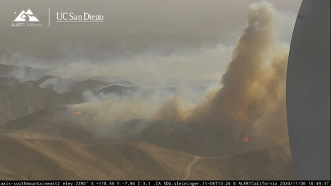
Image is from the South Mountain AlertCalifornia | UC San Diego fire camera.
• Reporter
An hour ago · Nov 6 at 10:40 AM
From VC Emergency the current road closures include:
- Northbound Lewis Road at Las Posas
- Eastbound Highway 118 at Wells Road
- Westbound Highway 118 at Tierra Rejada Road
• Reporter
An hour ago · Nov 6 at 10:24 AM
Incident Command is now requesting a hard closure on the 118 between Wells to Grimes Canyon. Request to close all access to arteries feeding into 118 to emergency vehicles and evacuations only. Additional strike teams were requested earlier.
• Reporter
2 hours ago · Nov 6 at 10:04 AM
Operations is requesting a hard closure at the 118 freeway, west at Wells Road, and East to Grimes Canyon Road.
• Reporter
2 hours ago · Nov 6 at 10:02 AM
Fixed wing will not be able to operate due to high winds. The fire is now 1000 acres, per Air Attack. Seven additional water dropping helicopters have been requested. Fire is expected to spot into the Camarillo Heights area, per Incident Command.
• Reporter
2 hours ago · Nov 6 at 9:59 AM
Incident Command has requested a hard closure on highway 118 between Balcom Canyon and Bradley Road. Air attack plane is now over the fire, along with two tankers and numerous copters.
• Reporter
2 hours ago · Nov 6 at 9:43 AM

An Evacuation Order has been issued for Zone 2, which is west of the earlier Evacuation Order Zone. For the zones’ parameters, see the Watch Duty Map or VCEmergency.
• Reporter
2 hours ago · Nov 6 at 9:40 AM
8 engines have been requested, any type, for life safety and structure defense. Report of structures being impacted near Bradley and Coyote. In addition, 4 additional fixed wing aircraft have been request, any type, with no divert, per Incident Command.
• Reporter
2 hours ago · Nov 6 at 9:35 AM
The evacuation zone for the Mountain Fire is now visible on the Watch Duty app.
• Reporter
2 hours ago · Nov 6 at 9:31 AM

An evacuation order zone has been issued by Ventura County OES. A map of the current evacuation order is shown above. Current evacuations can be found at https://vcoes.maps.arcgis.com/apps/dashboards/e15ca0d2737d43cea6514043e61f1a7c
• Reporter
2 hours ago · Nov 6 at 9:25 AM
Report that the fire has crossed Bradley and approaching the 118, per units on the scene.
• Reporter
2 hours ago · Nov 6 at 9:22 AM
Fire is now 250 acres with potential for 2000, with multiple structure threats and evacuations expected west of the fire, per Incident Command. Two copters have been ordered for structure protection.
• Reporter
2 hours ago · Nov 6 at 9:14 AM
Request to close Bradley Road, fire is spotting over Bradley Road and structure protection requested between Balcom Canyon Road and Solano Verde, per radio traffic.
• Reporter
2 hours ago · Nov 6 at 9:08 AM

Units on scene report a large scale brush fire. Pushed by strong East wind. Structures threatened and infrastructure threatened, upgraded to second alarm. Fixed wing was requested earlier. Both strike teams have been requested to scene. Evacuation orders have been requested by incident command for north of Bradley Road Balcom Canyon west to Kings Grove Road, North and South.
• Reporter
3 hours ago · Nov 6 at 8:58 AM
Wildfire is visible on the South Mountain Alert California | UC San Diego fire camera; units report a medium-moderate header and have requested CHP for road control.
• Reporter
3 hours ago · Nov 6 at 8:55 AM
Possible vegetation fire reported at Balcom Canyon, with smoke visible on Alert California cameras.
Fire conditions mild, but fire season is not yet over
Per Daniel Swain at http://www.weatherwest.com:
Due to recent precipitation across most of Northern California, wildfire risk is low during this first low RH/wind event and will likely stay below extreme levels during the second event as well from about the SF Bay Area northward (though with some caveats). This is the benefit of early season precipitation: even though most places in NorCal are actually running behind the seasonal-to-date average for Sep-early Nov (a decidedly noisy statistic!), places that have seen half an inch or more of rain recently will be in pretty good shape. Given that there has not yet been a seasonal green-up yet in most places and conditions will still be quite windy with low humidity for an extended period this week, there may still be some fires (especially in grassland settings) up north–but the likelihood of something big or concerning is fairly low up north (event compared to the mid-Oct event). With no further precipitation expected this week, however, and with the cumulative drying effect of several days of windy/low RH conditions expected to be substantial, it’s still a good idea to prevent errant sparks from igniting unplanned/unwanted fires during this period.
Yreka Green Waste Drop-Off November 2nd.
