Shoe Fire
Off Fenders Ferry Rd near Madrone Campground, S/W of Big Bend
Shasta County, CA
Acres
250
Containment
–
Status
Active
Updated an hour ago
Created by Watch Duty • Oct 9, 2024 at 1:30 PM
Evacuation Order – Level 3 – Go
LKH-1448-B
Evacuation Notes
• Staff Reporter
An hour ago · Oct 9 at 4:24 PM
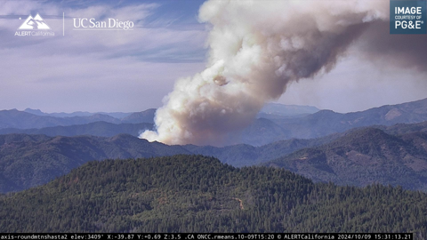
The fire has been updated to be approximately 250 acres per Incident Command w/ short range spotting, aircraft are working the left flank w/ tankers & hose lays are in progress on the right flank. Air Attack has ordered 1 night-flying HelCo (coordinator) + 3 type 1 night-flying helicopters for tonight due to the structure threat per radio traffic.
• Staff Reporter
An hour ago · Oct 9 at 4:00 PM
An evacuation order has been issued for Zone LKH-1448-B on Genasys. This zone can also be viewed on the Watch Duty map.
Update from Shasta-Trinity National Forest:
Resources are at scene at the Shoe Fire, which is currently 300 acres near the Madrone Campground near Shasta Lake. A full wildland and aircraft response has been deployed, including 8 engines, 2 crews 4 helicopters, 2 water tenders, multiple air tankers and 1 dozer.
No injuries have been reported and 1 structure is threatened. The public is advised to stay out of the area of as this is an active and ongoing incident. More information will be posted as it becomes available.
Link to their post
• Reporter
An hour ago · Oct 9 at 3:47 PM
Law enforcement has been requested to evacuate homes along Fenders Ferry Rd from the 299 side per radio traffic.
• Staff Reporter
2 hours ago · Oct 9 at 3:33 PM
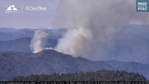
The fire has now been mapped at 200 acres by FIRIS Intel 12.
Their perimeter can be viewed on the Watch Duty map.
Please note that fire maps indicate the general burn area but do not detail the measures being taken to protect structures and homes. Even if a structure or home is within the marked fire perimeter, it doesn’t necessarily mean it has been damaged or destroyed. These maps are preliminary and may be updated.
• Staff Reporter
2 hours ago · Oct 9 at 3:19 PM
Incident Command has requested Evacuations for the area of Madrone Campground and structures North of the Campground
• Staff Reporter
2 hours ago · Oct 9 at 2:59 PM
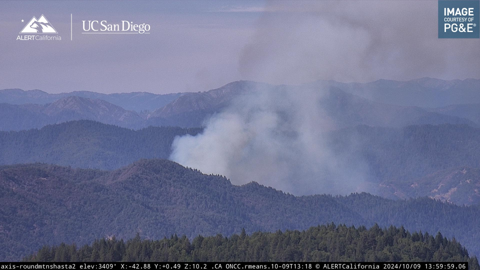
The fire has been mapped at 74 acres by CAL FIRE Intel aircraft.
Their perimeter can be viewed on the Watch Duty map.
Please note that fire maps indicate the general burn area but do not detail the measures being taken to protect structures and homes. Even if a structure or home is within the marked fire perimeter, it doesn’t necessarily mean it has been damaged or destroyed. These maps are preliminary and may be updated.
• Staff Reporter
3 hours ago · Oct 9 at 2:26 PM
The fire is now 50 acres with a Rapid rate of spread and a high potential, and the fire has jumped the “27 Rd” – per Incident Command.
3 additional water tenders requested.
• Staff Reporter
3 hours ago · Oct 9 at 2:18 PM
The fire is now approx 30 to 40 acres with a continued Moderate rate of spread – per Incident Command.
Incident Command has requested an additional 20 engines, 4 crews and 2 dozers.
• Staff Reporter
3 hours ago · Oct 9 at 2:01 PM
The fire is burning at a Moderate rate of spread along a creek – per Air Attack.
2 additional tankers and 1 additional type 1 copter have been requested.
Note the location has been updated to off of Fenders Ferry Rd near Madrone Campground.
• Staff Reporter
4 hours ago · Oct 9 at 1:30 PM
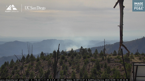
Resources are responding to a reported vegetation fire with smoke visible on the Shoeinhorse Mtn ALERT CA | UC San Diego camera.

