Month: October 2024
Siskiyou County Hazard Planning Meeting Agenda 11/4 Dunsmuir
Daniel Swain update on fire weather:
“An active fire season continued during this period–considerably later than usual in many parts of the Rockies, stretching already dwindling seasonal fire crews thin. In California, while fire activity has again picked up relative to the comparative August lull, no highly destructive fires have occurred over the past month despite vegetation moisture levels approaching or exceeding record dryness levels for October at times (though there have been a few near misses). And a fair number of risk-reducing prescribed burns have been able to go forward on the less windy days–always encouraging to see. Meanwhile, the Bridge and Line fires in the SoCal mountains (which originally ignited in early September) have continued to flare up on occasion, but generally these have been interior pockets of vegetation burning and have not burned any further structures.”
[…]
“Fire season continues across central and southern CA; risk will continue to spike during offshore wind events
Although we have not seen a major autumn wildfire outbreak yet in California, we also haven’t seen widespread season-mitigating (let alone season-ending) rainfall south of the about the I-80 corridor. In fact, vegetation moisture levels in parts of SoCal are now approaching record levels again following the early October heat and more recent dry winds–and even in the Bay Area conditions remain drier than average for the time of year. So fire season continues from about the SF Bay Area southward (less so to the north, where more widespread rain has fallen on a couple of occasions now and more will fall over the next week). That means that critical fire weather conditions can and probably will arise a couple of times over the next 10-14+ days, especially in the SoCal mountains and coastal plain where dry offshore Santa Ana winds (and relatively warm conditions) are expected periodically. Right now, none of the Santa Ana events in the forecast appear to be particularly extreme–but the magnitude of these events can be tricky to predict very far in advance as they are quite sensitive to the exact placement and depth of “inside slider” low pressure systems over the Great Basin (of which there will be at least a couple). So until widespread soaking rains arrive–and that is not looking likely south of about San Francisco for the next 2+ weeks–fire season will remain active and be punctuated by occasional higher-risk periods.”
NOTE: Significant rain is expected in our local starting Sunday and continuing for several days. Snow showers are possible. It won’t bring an end to fire season, but it does bring about a respite.
“Preemptive evacuation” urged in parts of Berkeley
Berkeley Hills residents urged to leave homes Friday night due to ‘extreme fire weather’
Berkeley Hills residents are asked to leave their homes by 8 p.m. Friday. BFD’s alert came as an acres-wide fire burned to the east in the Oakland Hills, prompting evacuations.
by Alex N. Gecan Oct. 18, 2024, 4:05 p.m.
- Click to share on Twitter (Opens in new window)
- Click to share on Facebook (Opens in new window)
- Click to print (Opens in new window)
- Click to email a link to a friend (Opens in new window)

The Berkeley Fire Department has declared a state of “extreme fire weather” from 8 p.m. Friday until 7 a.m. Saturday, recommending anyone in the Berkeley Hills preemptively evacuate their homes and head downhill before that 8 p.m. start time.
The alert came just a couple hours after an acres-wide fire began in the Oakland Hills near Interstate 580 and Keller Avenue, prompting evacuations in that area.
“Extreme fire weather” is a designation specific to Berkeley that takes effect when wind speed and humidity levels during a “red flag warning” — a National Weather Service designation, which took effect Thursday — “would produce especially risky conditions in Berkeley,” according to a notice that went out via AC Alert shortly after 3 p.m. Friday.
This is the first time extreme fire weather has been declared since the department started using the designation in 2021.
“These rare and dangerous conditions were last seen in October 2020. They exceed Berkeley’s threshold for Extreme Fire Weather — a Berkeley Fire Department trigger for additional preparedness steps beyond those we take during every Red Flag Warning,” according to the alert. “Because a fire that starts under these conditions could spread rapidly, we have activated our Emergency Operations Center, positioned additional firefighters and engines, and increased police patrols in the hills.”
The humidity is likely to stay low and sustained winds were forecast to blow 15-25 miles per hour.

BFD issued these recommendations for residents in the city’s most fire-prone ares:
- If you live in Fire Zone 2 or 3, consider relocating to a lower elevation until dangerous weather subsides — especially if you would have trouble getting out quickly during an evacuation. Leaving the area during periods of heightened threat is the best way to stay in control and minimize your risk.
- Stay with friends, family, or at a hotel until this dangerous weather subsides. BFD has partnered with Visit Berkeley to secure fire relief discounts for Berkeley residents at five local hotels during extreme fire weather. Additionally, there will be an increased law enforcement presence in the hills to provide added security as people leave their homes.
- Be ready to evacuate by using Berkeley’s Emergency Map: Download the Genasys Protect App to receive real-time alerts about any status changes or emergencies in zones you care about, and find your evacuation zone on the map website, which will be referenced in AC Alert evacuation messages. (Example: “BER-E044” is Berkeley Zone 44) and learn more about the city’s emergency alerting tools, such as the Outdoor Warning System.
- Have go-bags ready and placed by the door, and review evacuation plans with your household. Park off the street to leave roadways clear for emergency vehicles and back into your driveway or garage to make exiting quickly easier. Find more information on how to prepare on the fire weather and evacuation webpage.
- Secure outdoor furniture: Bring patio furniture, umbrellas, grills and other items that might blow away during high winds indoors or find another way to secure them.
“Please stay alert and be prepared to evacuate if needed. The strongest winds — and greatest danger — will be overnight. Leave your phone on, turn the volume up, disable ‘do not disturb’ settings and keep it nearby. Place go-bags and shoes by the door and review evacuation plans with your family before bed,” the alert reads. “If you feel threatened, leave immediately — do not wait for an evacuation order. Consider evacuating on your own if you see visible fire nearby or strong winds carrying smoke or embers through your neighborhood.”
Two fires in E. Bay that are of concern as strong offshore winds are expected
Hay Fire
6200 Block of Hay Road, East of Vacaville Solano County, CA
Acres 869
Containment
–
Status
Active
Updated 14 minutes ago
Created by Watch Duty • Oct 18, 2024 at 12:46 PM
• Staff Reporter
16 minutes ago · Oct 18 at 2:42 PM
The fire has been mapped at 869 acres by FIRIS Intel 12.
Their perimeter can be viewed on the Watch Duty map.
Please note that fire maps indicate the general burn area but do not detail the measures being taken to protect structures and homes. Even if a structure or home is within the marked fire perimeter, it doesn’t necessarily mean it has been damaged or destroyed. These maps are preliminary and may be updated.
All air tankers have now been released from the Incident.
Keller Fire
End of Sanford St in the area of Maynard, Oakland Alameda County, CA
Acres 10
Containment
–
Status
Active
Updated 16 minutes ago
Created by Watch Duty • Oct 18, 2024 at 1:38 PM
Evacuation Order – Level 3 – Go
OKL-E176, OKL-E203
Evacuation Warning – Level 2 – Set
OKL-E177, OKL-E178, OKL-E179
Update on Shoe Fire
Since midnight, McCloud has received .38″ of rain, and it’s safe to assume it is raining on the fire as well.
Shoe Fire
Off Fenders Ferry Rd near Madrone Campground, S/W of Big Bend
Shasta County, CA
Acres 3,937
Containment 7%
Status Active
Updated 41 minutes ago
Created by Watch Duty • 6 days ago • Oct 9 at 1:30 PM
Evacuation Order – Level 3 – Go
LKH-1448-B
Evacuation Notes
Genasys Evacuation Map
– Road Closures –
- Fenders Ferry Road at Pit River 7 Bridge: West-Bound Fenders Ferry Road (Also known as 34N17 – Forest Service Road 27) at the Pit River Bridge/Pit 7.
- Ferry Road is closed at McCloud Bridge: East-Bound Fenders Ferry Road at the McCloud River Bridge.
Shoe Fire: 2300 acres, 0% containment
Conditions remain favorable. Per Watchduty:
– Road Closures –
- Fenders Ferry Road at Pit River 7 Bridge: West-Bound Fenders Ferry Road (Also known as 34N17 – Forest Service Road 27) at the Pit River Bridge/Pit 7.
- Ferry Road is closed at McCloud Bridge: East-Bound Fenders Ferry Road at the McCloud River Bridge.
Shoe Fire 1,371 acres 0% containment Madrone Campground
Shoe Fire
Off Fenders Ferry Rd near Madrone Campground, S/W of Big Bend
Shasta County, CA
Acres
1,371
Containment
–
Status
Active
Updated an hour ago
Weather conditions remain favorable.
Created by Watch Duty • 1 day ago • Oct 9 at 1:30 PM
Fire Safe Council of Siskiyou County Zoom meeting for October 9th 2024
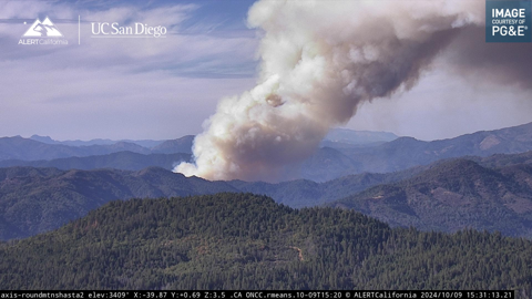
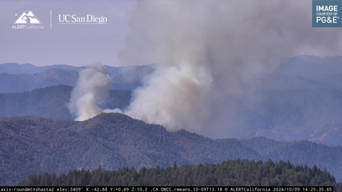
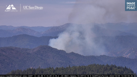
Shoe Fire near Big Bend at 250 acres
Shoe Fire
Off Fenders Ferry Rd near Madrone Campground, S/W of Big Bend
Shasta County, CA
Acres
250
Containment
–
Status
Active
Updated an hour ago
Created by Watch Duty • Oct 9, 2024 at 1:30 PM
Evacuation Order – Level 3 – Go
LKH-1448-B
Evacuation Notes
• Staff Reporter
An hour ago · Oct 9 at 4:24 PM
The fire has been updated to be approximately 250 acres per Incident Command w/ short range spotting, aircraft are working the left flank w/ tankers & hose lays are in progress on the right flank. Air Attack has ordered 1 night-flying HelCo (coordinator) + 3 type 1 night-flying helicopters for tonight due to the structure threat per radio traffic.
• Staff Reporter
An hour ago · Oct 9 at 4:00 PM
An evacuation order has been issued for Zone LKH-1448-B on Genasys. This zone can also be viewed on the Watch Duty map.
Update from Shasta-Trinity National Forest:
Resources are at scene at the Shoe Fire, which is currently 300 acres near the Madrone Campground near Shasta Lake. A full wildland and aircraft response has been deployed, including 8 engines, 2 crews 4 helicopters, 2 water tenders, multiple air tankers and 1 dozer.
No injuries have been reported and 1 structure is threatened. The public is advised to stay out of the area of as this is an active and ongoing incident. More information will be posted as it becomes available.
Link to their post
• Reporter
An hour ago · Oct 9 at 3:47 PM
Law enforcement has been requested to evacuate homes along Fenders Ferry Rd from the 299 side per radio traffic.
• Staff Reporter
2 hours ago · Oct 9 at 3:33 PM
The fire has now been mapped at 200 acres by FIRIS Intel 12.
Their perimeter can be viewed on the Watch Duty map.
Please note that fire maps indicate the general burn area but do not detail the measures being taken to protect structures and homes. Even if a structure or home is within the marked fire perimeter, it doesn’t necessarily mean it has been damaged or destroyed. These maps are preliminary and may be updated.
• Staff Reporter
2 hours ago · Oct 9 at 3:19 PM
Incident Command has requested Evacuations for the area of Madrone Campground and structures North of the Campground
• Staff Reporter
2 hours ago · Oct 9 at 2:59 PM
The fire has been mapped at 74 acres by CAL FIRE Intel aircraft.
Their perimeter can be viewed on the Watch Duty map.
Please note that fire maps indicate the general burn area but do not detail the measures being taken to protect structures and homes. Even if a structure or home is within the marked fire perimeter, it doesn’t necessarily mean it has been damaged or destroyed. These maps are preliminary and may be updated.
• Staff Reporter
3 hours ago · Oct 9 at 2:26 PM
The fire is now 50 acres with a Rapid rate of spread and a high potential, and the fire has jumped the “27 Rd” – per Incident Command.
3 additional water tenders requested.
• Staff Reporter
3 hours ago · Oct 9 at 2:18 PM
The fire is now approx 30 to 40 acres with a continued Moderate rate of spread – per Incident Command.
Incident Command has requested an additional 20 engines, 4 crews and 2 dozers.
• Staff Reporter
3 hours ago · Oct 9 at 2:01 PM
The fire is burning at a Moderate rate of spread along a creek – per Air Attack.
2 additional tankers and 1 additional type 1 copter have been requested.
Note the location has been updated to off of Fenders Ferry Rd near Madrone Campground.
• Staff Reporter
4 hours ago · Oct 9 at 1:30 PM
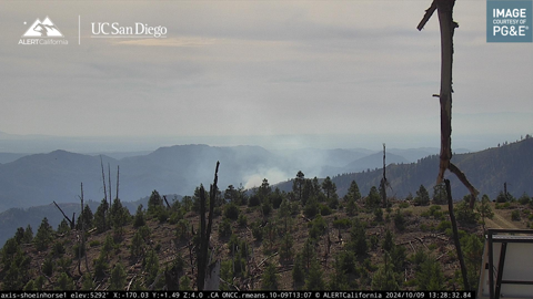
Resources are responding to a reported vegetation fire with smoke visible on the Shoeinhorse Mtn ALERT CA | UC San Diego camera.

