Fire Safe Council of Siskiyou County
Meeting Agenda
Wednesday September 14, 2022 @ 5:30 PM
Join Zoom Meeting
https://us02web.zoom.us/j/87850764956?pwd=UmkyKzY3NkFTL3dnMVJHUkNTRzhVZz09
Meeting ID: 878 5076 4956
Passcode: 138391
One tap mobile
+16694449171,,87850764956#,,,,*138391# US
+16699006833,,87850764956#,,,,*138391# US (San Jose)
I. Welcome and Meeting Purpose
II. Introductions and Announcements
III. In Attendance:
IV. Review and Finalize Agenda:
V. Action Items:
a. Code Red/Zone Haven Tutorial: Linda Scheban
b. Shasta Valley RCD/McKinney-Scott Project update: Lindsey Lyscheck
c. Happy Camp Community Center Jump Start Grant update: Abby Yeager
d. WTREX: Michael Hentz
e. CORE update
f. CALFIRE update:
g. USFS update:
h. Siskiyou County OES update:
i. Supervisor Nancy Ogren, Siskiyou County BOS update
j. Mike Wilson, Northern California Regional Coordinator for the California Fire Safe:
k. Siskiyou Prescribed Burn Association Update:
l. USDA-NRCS Yreka, Update: James Patterson, District Conservationist
m. Siskiyou County Air Quality-Eric Olson
n. Siskiyou County Sherriff’s update:
o. Pacific Power Update:
p. Scott River Watershed Council:
q. CHP update:
r. Siskiyou County Natural Resources update:
s. Steven’s (Wyden Amendment) Funding update:
t. Mount Shasta Bioregional Ecology Center:
u. Forest Management Task Force (FMTF) update:
v. Local FSC Updates:
i. Black Mountain
ii. Butte Valley
iii. Copco Lake
iv. Dunsmuir
v. Greater Weed
vi. Hammond Ranch
vii. Happy Camp
viii. Horse Creek
ix. Juniper Flat
x. Klamath River
xi. Lake Shastina
xii. Lower Scott River
xiii. McCloud
xiv. Mount Shasta Area
xv. Orleans/Somes Bar
xvi. Quartz Valley
xvii. Salmon River
Month: September 2022
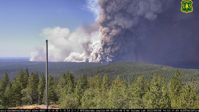
Extremely dangerous Mosquito Fire making runs at Foresthill, Volcanoville.
CA Fire Scanner
@CAFireScanner
· Sep 8
#MosquitoFire (#Foresthill, Placer Co, Tahoe NF) – Air Attack reporting ongoing structure loss in the Volcanoville area & fire is now also burning towards Foresthill after jumping the “Volcanoville drainage”. Fire is close to impacting Georgetown Fire Station 63.
Community Awareness: Zonehaven
FSCSC meeting September 14 at 5:30 pm
The Fire Safe Council of Siskiyou County’s Monthly meeting will be on September 14 starting at 5:30PM
Please join us for local fire updates, Code Red information, and more!
Topic: Fire Safe Council of Siskiyou County Monthly Meeting
Time: Sep 14, 2022 05:30 PM Pacific Time (US and Canada)
Join Zoom Meeting
Meeting ID: 878 5076 4956
Passcode: 138391
One tap mobile
+16694449171,,87850764956#,,,,*138391# US
+16699006833,,87850764956#,,,,*138391# US (San Jose)
Mosquito: “an extremely dangerous fire…firefighting is not effective under these conditions.”
This is an extremely dangerous fire and there are reports people are refusing to evacuate. If you are in an evacuation zone, or you can see flames, it’s (past) time to leave. #MosquitoFire is not playing around; firefighting is not effective under these conditions. #CAfire #CAwx
@CAFireScanner
· 50m
#MosquitoFire (#Foresthill, Placer Co, Tahoe NF) – Air Attack reporting ongoing structure loss in the Volcanoville area & fire is now also burning towards Foresthill after jumping the “Volcanoville drainage”. Fire is close to impacting Georgetown Fire Station 63.
Mosquito fire threatening several communities
#MosquitoFire (#Foresthill, Placer Co, Tahoe NF) – Evacuations to be upgraded to evac orders in the Todd Valley area per radio traffic, w/ an evacuation group being established. 20 additional engines just requested immediate need.
Red Flag Warning for Josephine, NW Siskiyou Counties
CRITICAL FIRE WEATHER INFORMATION FOR LATE THURSDAY INTO SATURDAY MORNING FROM THE NATIONAL WEATHER SERVICE IN MEDFORD PLEASE READ THE FULL POST:
“A Red Flag warning is in effect for Josephine and NW Siskiyou counties Thursday. Portions of Douglas, eastern and northern Jackson and western Klamath counties Thursday night through Saturday morning. In addition to the restrictions on use of power tools, parking on dry grass, etc., if planning on camping in the mountains follow the following. Research fire restrictions on campfires, generators, and firewood cutting ahead of time. If you are allowed to have a campfire, never leave it unattended, even for a moment. Dry windy conditions will last overnight. Be certain your fire is completely out and cold to the touch when you leave or go to bed!”
RED FLAG WARNING REMAINS IN EFFECT FROM MIDNIGHT THURSDAY NIGHT TO 10 AM PDT SATURDAY FOR EAST WIND WITH POOR OVERNIGHT RH RECOVERY AND STRONG GUSTY WIND AND LOW RH FOR FIRE WEATHER ZONE 623…
* AFFECTED AREA: For the Red Flag Warning Thursday night into Saturday morning, nearly the whole zone, but especially the ridges.
* WINDS: East 7 to 14 with gusts to 25 mph.
* RELATIVE HUMIDITY: 6 to 14 percent in the daytime. Night time recoveries 20 to 25 percent.
RED FLAG WARNING REMAINS IN EFFECT FROM MIDNIGHT THURSDAY NIGHT TO 10 AM PDT SATURDAY FOR EAST WIND WITH POOR OVERNIGHT RH RECOVERY AND STRONG GUSTY WIND AND LOW RH…
Gusty winds combined with low humidities will bring critical conditions to the Illinois Valley and lower Klamath Valley Thursday. Low humidities and gusty east winds will also occur over and near the Cascades Thursday night through Friday night. A Haines of 6 over the Rum Creek fire will create Red Flag conditions there Friday.
* IMPACTS: Any fires that develop will likely spread rapidly. Outdoor burning is not recommended.
* AFFECTED AREA: The Southern Oregon Cascade and Siskiyou Crests and associated foothills, along with the Umpqua Divide. This does include the Windigo fire. Eastern and northern portions of fire weather zones 616, and 622, eastern portion of 621, with most of fire weather zone 623, and all of fire weather zone 617. Much of the Illinois Valley and surrounding hills, including the Rum Creek Fire Thursday. The Friday Red Flag only includes the Rum Creek Fire.
* WIND: East 10 to 15 mph with gusts to 30 mph.
* HUMIDITY: Daytime Humidities 8 to 14 percent. Night time recoveries 19 to 24 percent.
RED FLAG WARNING REMAINS IN EFFECT FROM 11 AM TO 8 PM PDT THURSDAY FOR ISOLATED TO SCATTERED DRY THUNDERSTORMS ON DRY FUELS FOR FIRE WEATHER ZONE 280…
The National Weather Service in Medford has cancelled the Red Flag Warning for this evening for isolated to scattered dry thunderstorms on dry fuels.
* AFFECTED AREA…For the Red Flag Warning on Thursday, the Klamath River valley and surrounding areas from Seiad Valley to south of Happy Camp.
* WIND: Northeast 10 to 15 mph with gusts to 30 mph.
* HUMIDITY: 6 to 13 percent.
* DETAILED URL: View the hazard area in detail at https://www.wrh.noaa.gov/map/?wfo=mfr
PRECAUTIONARY/PREPAREDNESS ACTIONS…
Avoid tossing burning cigarettes on the ground, parking hot vehicles on dry vegetation, and using equipment that can cause sparks. Follow all fire restrictions. Find links to restrictions at weather.gov/medford/wildfire. One less spark, one less wildfire.
Gather your fire evacuation kit now. Collect essentials you don`t want to lose and prioritize your checklist. Visit ready.gov/kit for more information.
Familiarize yourself with your evacuation plan. Where will you go? How will you get there? Who will you call to let others know your are safe? Visit ready.gov/wildfires for more information.
A Red Flag Warning means that critical fire weather conditions are either occurring now or will shortly. These conditions promote rapid spread of fire which may become life threatening. Evacuate if ordered to, or if a fire threatens
RFW for most of region
Extreme heat continues, low humidities, poor overnight recovery, gusty winds and possible dry lightning make for poor outlook.

Dry lightning possible Wednesday

Gusty winds to add to fire problems tomorrow
FIRE WEATHER WATCH IN EFFECT FROM TUESDAY AFTERNOON THROUGH TUESDAY EVENING FOR STRONG GUSTY WIND AND LOW RH FOR FIRE WEATHER
AFFECTED AREA…Fire weather zone 280, including the Mountain fire
WIND…Northwest winds 10 to 20 mph with gusts as high as
30mph.
HUMIDITY…6 to 13 percent.